Mountview Falls
Description
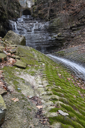
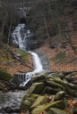
A storm drain tributary to Chedoke Creek flows over Mountview falls and travels down a ~200m section of unsightly erosion-protection cladding called “Fabriform® Filterpoint Revetment” before flowing over a small, second, artificial waterfall, Lower Mountview Falls.
From there, the creek enters a culvert where it immediately plummets, then flows beneath HWY403 before joining Chedoke Creek. In the decades since it was laid, several sections of the revetment have, ironically, collapsed due to erosion, and the creek now flows underneath the eye-sore at those sections, promoting further erosion.
Names/Sources ‡
Goulding Falls (LOCAL)Mountview Falls (CoH)
Media
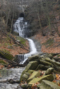
 | Mountview Falls | 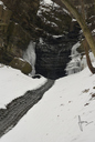 | Mountview Falls - part frozen |
 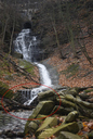 | Mountview Falls - revetment failure | |
 | Mountview Falls - Main Abomination | 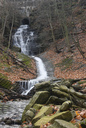 | Mountview Falls - Main Abomination |
 | Mountview Falls - Main Abomination |
| Location | 79°55'17.191"W 43°14'43.786"N |
| Park | Chedoke Radial Trail |
| Watercourse | Tributary of Chedoke Creek - West Branch |
| Form | Complex Classic Cascade |
| Flow | Seasonal |
| Crest Restriction : Access | None : Moderately Easy |
| Foot Restriction : Access | None : Easy |
| Height : Width (m) | 10.00 : 6.00 |
| Height : Width (ft) | 32 : 19 |
| Authority / Owner | City of Hamilton |