Darnley Cascade
Description
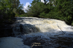
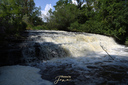
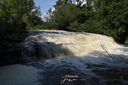
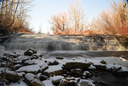
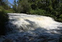
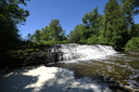
Darnley Cascade is named after Lord Darnley as the Darnley Grist Mill, completed in 1813 by Scottish settler James Crooks, claimed to be a descendant. It is situated just below the Christie Lake Dam and at 225m AMSL, is the waterfall with the highest elevation in Hamilton.
Notes
The source for Darnley Cascade is Christie Lake and is controlled by the dam sluices. For this reason, the water level can increase dramatically without notice, inundating the area at the foot of the falls and taking the unwary by surprise. Always be on the lookout for a sudden increase in flow if you are in this area.
Other Names
Stutt's Falls (Alternative Local Name)Media
Trails
Crook's Hollow Parking to Darnley Cascade (Return) 1.2km| Location | 80°0'24.455"W 43°16'37.952"N |
| Park | Crooks Hollow Conservation Area |
| River | Spencer Creek |
| Form | Curtain Cascade |
| Flow | Year Round |
| Crest Restriction : Access | None : Easy |
| Foot Restriction : Access | None : Moderate |
| Height : Width (m) | 4.00 : 22.00 |
| Height : Width (ft) | 13 : 72 |
| Authority / Owner | Hamilton Conservation Authority |